Entry #25 – Furthest North, Setting the Record – Norwegian Odyssey – July 20, 2016
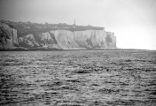
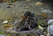
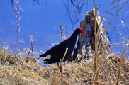
Lat 77.00° N, Hornsund Fjord, Svalbard: During the night I’m awakened by an unusual sound, as if Migration has been boarded by multiple intruders. I get up to take a look and see we are surrounded by a riot of small pieces of ice, bergy bits, and they are gently bumping into the hull. Their presence is accompanied by another peculiar sound, a distinctive crackling, tinkling and popping, something like the sound ice cubes make when dropped into room temperature water, only much louder. Hours later, in spite of the curtains on my ports, light streams into my cabin (this time of year the sun never sets, a blessing for sightseeing and passagemaking, but a curse for sleeping, one tends to go to bed very late and get up early), I can stand it no longer so I get up and look out, I’m greeted by absolute calm and drenching sunshine, it’s a glorious day and ideal for our passage to Bellsund, a day’s cruise away. We weigh anchor and are steaming north by 0600. As we depart the calm conditions beg for a final close pass on the glacier face, we take Migration in through the ice and memorialize the event with the drone, capturing some stunning images.As we depart Hornsund the vistas grow more enchanting with each passing minute, swirling mist envelopes moss covered hillsides and rocky coastline, with sprawling glaciers, one after the other, filing our starboard side bridge windows as Migration plies her way further north. Clutches of black guillemots and the occasional eider duck dot the glassy calm surface as we slip by; the air has a scrubbed, crisp scent, a mixture of cold sea salt and pristine land far from the effects of civilization. Svalbard is truly a land of glaciers, with over 2100, and the world’s third largest, some of which are 1,800 feet thick. We pass by two that are especially remarkable, one, Austre Torellbreen, veritably envelopes a mountain, a phenomenon called a nunatak, on its way to the sea, while the next, Vestre Torellbreen, is epic in its scale, its front seemingly miles long. We opt to detour for a closer look at the latter, motoring up to the face and, once again, launch the drone to capture images from aloft. As we begin to make the turn to starboard, into the Bellsund Fjord complex, a pod of fin whales, adults and minors, crosses our bow, arching and blowing several times. We drop anchor in Vestervågan, 77.30°N, at the mouth of Recherchebreen Glacier, setting the anchor “uphill” on a glacial moraine once again, and shut down the engine at 1630, with five glaciers in view. It’s drizzling now but there is no wind, which is welcomed. We launch the tender and go ashore to explore the remains of a nearby long-abandoned coal mining camp. There we find the very essence of forlorn, a decaying timber house with brick chimney and two grave sites, on a barren windswept bluff above a shingle beach. The backdrop, however, glaciers and snow-capped peaks is inspiring.Longyearbyen, Adventfjorden, Svalbard’s capital, 77.13°N: After a day’s run we arrive in Longyearbyen, “Longyear City” named after an American mining magnate from Boston, John Munro Longyear, who financed the settlement’s first coalmine, the Arctic Coal Company, in 1906. Longyear eventually sold the operation to a Norwegian company, Store Norske Spitsbergen Kulkompani, SNSK, which still essentially owns much of the town today. Picturesque it’s not; this is a gritty, working former coal mining village that now primarily services the region’s tourism industry, including large and small cruise ships, many of which we’ve encountered during our stay here, and provides some lodging for a nearby Russian-operated coal mine at Barentsberg (stay tuned for a report on our visit to that piece of Cold War history), about 300 miners, mostly Russian and Ukrainian, live here and commute to the mine. Dating originally from the 1920s, an ingenious and now defunct, but fully intact and intricate gondola system, supported by dozens of timber derricks, which traverse a hillside from the coal pier to the power station, it’s reminiscent of an HO model railroad, once carried coal from the town’s mines to the port. It’s now a protected cultural monument. During WWII the mines and anything of strategic value were first destroyed by Norwegian troops, to prevent them from being used by the Germans, and then shelled by the German battleship Scharnhorst, with an invasion of troops afterward, during which most of the remaining buildings were destroyed, and the Norwegian garrison overrun, although a small allied force continued to skirmish with the Germans here throughout much of the war (how miserable that must have been). The town and mins were rebuilt after the war and remained firmly in the grip of SNSK through the 80s, it was purely a company town, complete with its own script or currency. Slowly that changed, however, and today only one of the original seven mines remains open, providing coal for the power plant and a small amount for export. Tourism has returned as Longyearbyen’s primary business, as it predates even coal mining, the first cruise ship visited here in 1892. It’s also the home of the archipelago’s only airport, the one I’ll fly out of in a few weeks. No small operation, it’s capable of handling Scandinavian Air’s 737s which fly exclusively to the Norwegian mainland.
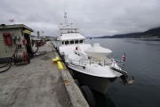
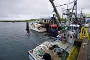
At the time of our arrival the harbor is populated with over a dozen cruising sailing and motor-sailing vessels, some private other eco-tourist based. Other than Migration there appears to be but one other recreational power vessel, a handsome-looking Norwegian former fishing vessel named Isbjørnen (Polar Bear), with a polar bear stenciled on the bridge wing.
The water in the anchorage is among the most turbid I’ve seen in Svalbard, or anywhere else for that matter, it’s positively opaque and a muddy brown hue, run off from a river that carves its way through the center of the town, itself the product of snow melt from the town’s backdrop, a snow capped peak. This is a commercial port in every respect, and a stark contrast from the areas we’ve passed through in the last few days. We go ashore to treat ourselves to a meal off the boat and get a taste of this locale. The town of 2,000 inhabitants is the furthest north civilian year ‘round settlement in the world, it’s grimy and on the edge in many respects, a cross between an eco-tourism ski village and a coal mining town. Every car, truck and bus that drives by us as we walk the main drag is positively filthy, the roads are bordered by what looks like black sand blasting media, which must play havoc with everything mechanical. Many parking places are equipped with electrical outlets, not for electric vehicles, I see none of those, most everything is diesel; these are used for block heaters during the long, dark frigid winters. Rooms used for sleeping in prefab homes and above shops are easily identifiable; their windows are covered with aluminum foil, a deterrent against the relentless 24 hour summer daylight. While it is interesting in its own right, Longyearbyen is a place you stop at on your way to Svalbard.
Entry #24 – Furthest North, Setting the Record – Norwegian Odyssey – July 19, 2016
Bjonahamna and Pyramiden, Svalbard 78°39N.
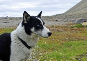
By 0700 George and I are headed ashore for breakfast at the Radisson hotel (the northern-most chain hotel in the word, this one was used for the Lillehammer Winter Olympics and then moved here afterward); our real mission is to access their high speed internet for weather and ice reports, as well as e mail, as we’ve been on satellite for the past week, which makes dial up look blindingly fast. When we walk into the hotel we are greeted by a large set of shelves affixed to the wall in the lobby, filled with shoes. A sign explains, in order to enter this Radisson guests and visitors are asked, in the tradition of Svalbard homes, to remove their shoes. Back at the boat and a short three hour steam and we reach the Bjornahamna anchorage. As Migration makes her way into this compact cove, located at the base of 1000 foot cliffs filled with swirling fulmars and terns, we spy two large antlered reindeer strolling casually on the beach. There are a few small huts here, one of which has a boat on the beach. We nose our way in, drop anchor and tender ashore. We meet the residents, a man and a woman and their husky (he is there to warn them of approaching polar bears, they say); they are just packing up to head back to Longyearbyen after a fishing weekend, and they proudly show us their catch, a lovely Arctic char. I note that she wears a heavy leather LL Bean belt, from which hangs a holstered semi-automatic pistol, while a rifle leans against the outside of the hut.We walk inland to get some exercise and on the advice of the residents, hike part way up the cliffs to gain a better view point. The ground is spongy tundra, mostly moss and grass, which is scattered with boulders, some as large as SUVs, which have rolled down from the mountain. Most are gray and reddish brown and covered with iridescent orange moss, but every once in a while we encounter a nearly pure white stone that has the consistency of a bar of soap, when picked up it crumbles easily. We continue our hike upward, with the slope becoming steeper and turning to loose rock; it’s arduous and at times uncertain. We finally reach a plateau with a commanding view of the fjord, and stunning layer cake geological formations, and there we rest and take in the vista before heading down via a different, less arduous path, and toward a beach. As we are walking we nearly stumble, literally, into the two grazing reindeer, we are downwind so they neither hear nor smell us, and their natural camouflage is so effective we simply fail to note their presence until we are virtually upon them. We hunker down and they walk to within 20 feet of us, and while the sound of my camera shutter arouses their suspicion, they continue feeding. Eventually we grow tired of crouching and stand up, and our visitors casually amble off.We return to Migration, weigh anchor and point our bow toward our next destination, the Russian mining ghost town of Pyramiden. Stay tuned, this one is going to be interesting. Das vidanya.
Jul 19
Entry #23 – Furthest North, Setting the Record – Norwegian Odyssey – July 12-13, 2016
Svalbard, 76° north latitude: Migration makes landfall at Sørkappøya, Svalbard, 24 hrs and 174 nm after departing Bear Island (Bjørnøya in Norwegian). Mercifully the conditions are far better than the first leg to Bear Island waves are just 4-5 feet, with wind speed ranging from 5-15 kts. Although Neptune gets the last word on this leg, for the last few hours winds wind up to 47 knots, the seas become very sloppy and visibility drops to a few hundred yards in mist and spume, waves break over Migration’s bow and pelt the windscreen repeatedly, until we are in the lee of Svalbard’s Vesle Svartkuven peninsula. Outside air temperature has dropped to a frosty 33F, which is fitting as Svalbard means “cold coast”. All the while I’m sitting in a cushy helm chair in Migration’s pilothouse, in a T shirt and wearing bedroom slippers, sipping a cool drink, while typing away on my laptop. It’s good to be aboard a comfortable vessel. Fifteen miles out we pick up two escorts, a flock of fulmars and a pod of dolphin. The latter crisscross in front of our bow, and I can only think they must be frustrated by our stately 6 knot pace, while the fulmars repeatedly dive bomb our wildly fluttering red and white Nordhavn 30,000 mile pennant. Our fist anchorage, Hornsundet, a glacier strewn indentation in the Archipelago’s southwestern corner, was once a whaling station and now is known to be a haunt of polar bears.
Lat 77.00° N, Hornsund Fjord, Svalbard: Once making the lee of the mainland and mountains Migration encounters katabatic gusts in excess of 55 knots. The wind is good for one thing, however; it’s blown out the fog and cloud cover, revealing a brilliant azure sky and sunshine, which reflects off snow-capped peaks and coastal glaciers, three of the latter can be seen at once. We beat our way through choppy waves and a 30 knot head wind for nearly three hours to what we believe will be a semi-protected anchorage; we quickly abandon this notion, however, seeing its exposure to these winds upon our turn into the bay. We then make for another possible anchorage adjacent to a Polish Arctic research station. But even this location proves unsound; an easterly wind is blowing ice from the Hansbukta glacier into that anchorage. After doing a slow cruise along the face of the glacier, we finally opt for a tiny inlet called Kamavika, across the glacier tongue, the same cove where, according to the Norwegian cruising guide, long-time friends Dave and Jaja Martin anchored in their 34 foot sailing vessel many years ago. It proves ideal; we’re able to set the anchor going “uphill” over an ancient glacial moraine. The wind here is just 12 knots, and it offers precisely the respite we need to rest and recuperate after an arduous passage. We are joined in the anchorage by a 50-foot Swiss-flagged sailing vessel with a crew of seven. I watch as the crew furl their sails, they are bundled up like Micheline Men, and I can only imagine what the crossing experience must have been like for them in the conditions we encountered. The next morning we awake to relative calm with winds ranging between 10-15 knots, and an overcast sky. During the night we could feel Migration rock periodically, reacting to the “wake” created by our neighbor, the calving glacier. Our decision to avoid the research station anchorage turns out to have been a sound one, the overnight wind has pushed into this cove a large collection of bergy bits and brash Ice.
Jul 12-13
Entry #22 – Furthest North, Setting the Record – Norwegian Odyssey – July 11, 2016
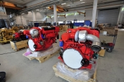
Like a kid in a candy store” aptly describes today’s experience. I traveled to Sovik, Norway, near Aalsund, the home of Nogva Motorfabrikk AS, one of Norway’s largest diesel engine distributors, and much much more. The purpose of the visit was to evaluate one of their product lines, Scania, for use in a vessel to be built for a client. He and I made arrangements to visit Nogva’s facilities to meet with an application engineer and assess the suitability of the Scania for this new build. In addition to Scania, Nogva also represents John Deere, Cummins, and Nanni. More impressive, however, are three other products they actually manufacture, Nogva transmissions or “gears” as they are known in the industry, keel coolers, and Nogva controllable pitch propellers, often simply referred to as “CPP”. These two products, gears and CPP, are complementary as CPP must be used with specialized gears. Nogva casts their own gearbox housings, propeller blades and hubs, and I watched them assemble and test these, as well as preparing Scania, Deere and Cummins engines for propulsion and generator applications. The facility is as clean as an operating room, the machine and assembly shops are state of the art, and staffed by knowledgeable folks who were able to answer every technical question I threw at them. The waterfront facility also possesses the ability to haul vessels and work on them in an indoor shed, as well as pier-side facilities. While I was there two 300+ foot oil rig support vessels were in the final stages of construction and fit out. It was enough to make this gearhead giddy with excitement. The bucolic countryside vistas and ocean views made this visit even more enjoyable.
Jul 11
Entry #21 – Furthest North, Setting the Record – Norwegian Odyssey – July 9, 2016
It’s mostly gray, foggy and overcast now, with low clouds enveloping the surrounding mountains, Tromso, at 69°39’ north latitude, 3° above the Arctic Circle, isn’t exactly a shirt sleeve environment, a warm day is 60°F. In my walk around the town yesterday, however, I noticed that locals are easily distinguished from visitors because many of the former often wear just a T shirt.A statue of famous Norwegian polar explorer Roald Amundsen, he won the “race” to the South Pole, beating Britain’s famed Robert Falcon Scott by more than a month, adorns one of the town’s squares. He is also the first person to reach both poles, and the first to successfully traverse the Northwest Passage. Amundsen, truly a giant among polar explorers, was lost on an Arctic rescue mission in 1928, with no trace save pieces of his float plane, which washed up at Tromso.Tromso’s harbor includes a collection of interesting vessels, it’s primarily commercial, with a small contingent of pleasure vessels; both power and sail, with features unique to the region and climate, most include full canvas enclosures, along with a handful of tour excursion vessels. There are also two research vessels in port as well, one from France, the 240 foot RV L’Atalante, and another, quite small, just 50 feet, the RV Clione, a motor sailor, registered in Amsterdam, the Netherlands; in Tromso for service work, she’s bound for Svalbard as well, where she stationed. Norway’s “mail boat”, a small ship which transits the coast year ‘round, stops here as well, carrying passengers, tourists and cargo. One vessel berthed nearby, named Northabout, an aluminum sailboat with a sloped “ice breaking” bow, is preparing to transit the “other” passage, the Northeast route, the one above Russia, and then the Northwest Passage, part of the Polar Ocean Challenge education and research group, she’s essentially circumnavigating the North Pole. Her bow rail is adorned with a collection of stuffed animal mascots, which she will no doubt need on a journey as bold as this one. Many of the vessels, both recreational and fishing, are made of timber and in most cases a portion or all of the hull and deck are simply varnished rather than painted over. All in all not your average harbor.
Yesterday, in preparation for our passage, we traveled to the fuel dock and took on 2413 gallons of diesel fuel, at a quite reasonable $1.74/gallon, just 56% of the typical price, which normally includes taxes. The discount was made available to us as a result of our destination, Svalbard, which is a tax-free zone.
2330 PM, underway passing through Langsundkjeften channel, a 5 hr trek to open water. We departed Tromso at 2130, in light rain and fog. We leave now in order to make a perceived but somewhat tenuous weather window. Winds are forecast to be light, but wave heights at times significant, as much as 9 feet, however, no wave period is available so there’s no way to know just how bad it will be.We pass by isolated farmsteads and what look like summer homes, snow streaks down the mountainsides, which are wreathed in fog and clouds. We also encounter the occasional commercial ship and ferry, as well as an enormous, brightly lit, moored oil rig.After roughly 43 hrs, and 256 nm underway we make landfall at Bear Island. The passage qualifies as one of the most miserable I’ve ever undertaken, 8-12 foot waves, with a short period, on the nose and 20-25 knots of wind (so much for our forecast). Migration handled it well with all systems performing well and no failures; her crew on the other hand was laid low for much of the time. As for me, let’s just say I became intimately acquainted with the pilothouse head and leave it at that. There is one saving grace, because of our high latitude it never gets dark, which means you can see and prepare of every wave.
Upon our arrival we seek shelter in a cove called Sørhamna on the south east tip of the island. It’s foggy when we arrive, and cool, 37F (53F when we departed Tromsø) and shortly after we arrive the fog gets thicker. Still, determined to get some fresh air we launch the small inflatable tender and cruise the cove, we motor along cliffs festooned with nesting fulmars and puffins, the water around us is filled with bobbing birds, and most aren’t shy, some swim right up to Migration’s swim platform, however, we are careful not to lose sight of Migration for fear of not being find our way back.
Unfortunately we are afforded little time to lick out wounds; we have a weather window that calls for our departure in just a few hours. We take showers (never underestimate the restorative power of a hot shower), eat and catch up on chores before weighing anchor once again.
Jul 9
Entry #20 – Furthest North, Setting the Record – Norwegian Odyssey – July 7, 2016
My first stop on the way to Svalbard, Aalesund is located in the southern part of Norway, on a nearshore island. To reach the town from the airport one must drive through two undersea tunnels, one of which is over 500 feet deep. In order to reduce the length of the tunnel and its grade, a 360° spiral roadway forms one entrance. The scenic town, with a population of approximately 45,000, is rich in seafaring and fishing heritage. As is often the case in high latitudes, one finds it difficult to go to bed too early thanks to the late sunsets. After dinner as tired as I was from my travels, I couldn’t resist a walkabout of the waterfront, the lighting from the low hanging sun was lovely and simply beckoned the camera’s lens.
Jul 7
Entry #19 – Huatulco – Mexico – January 2016
Mexico. I know, it has a bad reputation, every day the media treats us to a host of stories involving mayhem, drugs and violence. The first time I went, about seven years ago, to a place called San Louis Potosi, in the center of the country, I was prepared for the worst. I was surprised, however, to discover that it was worlds away from what I expected. Since then I’ve been to Mexico several times on business and every experience has been enjoyable, even if the touristified areas I’ve gone on business haven’t always been my style.
Not long ago Sandy and I decided we needed a quick, easy and warm mid-January getaway. Two years ago I traveled to a small seaside village called Huatulco to carry out a vessel inspection. Every recollection I had of this area was simply delightful, ideal weather, not over-developed, friendly locals, great restaurants and inexpensive. Therefore, in record time we hastily threw together a trip to this locale. We stayed at the same thatch-roofed inn in which I’d resided previously, it has just eight rooms, and is situated on a cliff overlooking the ocean, perfectly positioned to capture every sunrise. It’s owned and operated by a friendly Canadian couple who have lived here for many years, this is their home. Within a fifteen minute walk of the inn lies a beach that simply must be seen to be believed. A gentle white sand crescent, fringed by steep rocky cliffs and forest, covered each morning in tracks left by turtles on nocturnal egg-laying missions. While those features are idyllic to be sure, the best part of this beach is its seclusion, it was a rare day that we spent there when we didn’t have it entirely to ourselves. There’s a reason for this, one that I hope never changes. While the walk is just fifteen minutes, one must pass through a forest track that at times is steep; it’s a good workout, one my fitness tracker commended me for every day.
The small village of Huatulco is a fifteen minute drive from the inn. We opted to forgo a rental car, however, because every cab ride is just $2.50. The town consists of a main square surrounded by shops, most of which offer local crafts, pottery, and woven items, and restaurants. On our first foray into town we strolled into a small café for lunch, one I had recalled visiting and enjoying on my previous visit. We were the only patrons, three staff members were there, yet none of them spoke English. Using my dreadful broken Spanish, and some sign language, however, we managed to have a delicious meal (I don’t think there was a choice) of soup, and fish, and a few beers for about $12. This typified virtually every experience we had in town, extremely friendly and helpful locals, and not too many tourists, who are primarily Canadian. I’m not sure we encountered another American during our stay. We returned to the town each evening for dinners, after which we’d go walking. Reminiscent of scenes I’ve encountered in Southern Europe, the square was always filled with people, families with children running and playing, and couples strolling arm in arm. Ice cream vendors pushed insulated carts (remember these?) selling their frozen treats. It was idyllic; and Mexico is not what you think.
As an avid birder I was surprised by the variety of birdlife, many examples of which were visible from our room’s veranda.
The inn we stayed at is for sale, so if you are looking to chuck it all and live the simple life, here’s your chance.
Travelogue Entry #19
Entry #18 – Tasmania – Australia – 29 November 2015
The weather report isn’t promising, and sadly it’s accurate. I awake an hour before my alarm and toss and turn, I finally get up, look out the window and see gray with some clear sky, I’m hopeful. At 0500 I head to the lake and it’s a bust, the sky is gray and the sun never makes an appearance. I walk some of the tracks until 0645 and then head to the lodge for breakfast, after which I return to the lake; however, as I drive up it’s drizzling, bordering on raining. I turn back and go to an intermediate lot called Waldheim, and while it’s only a few minutes from Dove Lake, it isn’t raining. I get out, load up my camera gear and begin walking. I take a board walk through a field and when I come to a junction that says Maryland and Hounslow Heath Track, 3 hrs, I think ‘why not?’ I neglect to note the difficulty level and only once I’m a third of the way into it do I consult my map, where I discover it’s shown in magenta, which is grade 4 (out of four), “Bush walking experience recommended. Tracks may be long, rough and very steep, directional signage may be limited”, all of which turns out to be an understatement.
At this stage, an hour in, I’m having second thoughts about continuing and about just where I am (the track is marked, albeit not well, by periodic reflective posts or small orange triangles, however, I lose these repeatedly); foolishly I leave my iPad with tracking map in the car. The path is more river and bog than track, by feet are soaked and so are my pants (I forgot my rain pants, arrggh), however, the greatest difficulty is presented by the brush, when the description mentioned bushwhacking it means it, it is veritably impassable, at some stages I can’t see the path, I can only feel it with my feet, which are often shin deep in water thanks to the rain, which is now falling more steadily. Even though I’m only a third of the way in, the thought of turning back is, well, unthinkable. Every step requires double the effort, lifting my body up vertically, as I’m gaining elevation, as well as pushing through brush. I press on, however, as thoughts of Charlie Allnut pulling the African Queen through the Ulanga’s reeds and the Shackleton, Worsley and Crean traverse of South Georgia (a short section of which I retraced some years ago) come to mind. If they can do it so can I, I resolve. The route becomes ever steeper, I’m breathing heavily, however, I resist stopping to rest for fear of becoming chilled. Fortunately, other than forgetting my waterproof pants, I dressed right, warmly, and in layers with a waterproof jacket. While my feet and legs are wet, my upper body is dry and warm, and I have food to feed the calorie furnace. The temperature ranges between 55-48° F. Reluctantly I concede that I’m not sure where I am, the map and my surroundings don’t seem to match. While I don’t have my iPad, I do have a phone; I give in and decide to consult Google Maps. When I look at the phone’s screen I’m crestfallen, there’s no signal. After 1.5 hrs I reach a sign, the first I’ve seen, which at least confirms where I am, and that I’m almost certainly on the trail I believe I’m on, and I’m at the halfway point. How much harder can it get, I think. Then I begin passing clumps of snow. I console myself with the thought, ‘I have an EPIRB, at least if I got hurt I could set it off’.
Rain rolls though in patches, with fig, I’m high enough now where I’m actually in the clouds. Still the trail ascends and I’m just incredulous, ‘Will I never reach the crest’ I say out loud. I’ve eaten some of my food, an apple and a biscuit, but I have plenty left. I stop briefly to have a snack. Finally, after 2 hours I break out of the brush and onto a high grassy plateau spotted with snow, and in spite of the rain the view is good, it even looks to be clearing to the south, toward Cradle Mountain, I can see the Western Tiers range in the distance. I also have a cell phone signal, I send Sandy an e mail telling her where I am, and letting her know in spite of the arduous ness of the hike, I’m having fun (I exaggerate). I walk the heath for about 25 minutes, and then begin to descend, once again into the bush, it’s easier going downhill, but it still requires herculean effort and I’m unable to see where I’m stepping. The landscape transforms once again into a temperate rainforest, with large trees, ferns and piles of moss. The trail is still more stream than track, so I try to step on the many roots that cross it, however, I soon realize that’s folly, as they are very slippery, it’s actually preferable to aim for the puddles, as they are depressions and therefore offer better and safer footing. My feet are soaked anyway so it doesn’t matter.
Finally, after roughly three hours I reach a small foot bridge and a building, I’m at civilization, but still a half hour from my car. I continue on, but now over familiar open ground. Ten minutes from the terminus of the hike I spot two wombats, what appears to be a mother and baby, feeding. They pay no attention to me as I photograph them both, and with that a steady rain begins to fall once again. During the entire trek I encounter not a single soul.
Within 10 minutes I’m at my car, tired but satisfied. Instead of leaving the park and heading back to my cabin I reason, I’m already wet and the day is young, I’ll return to the lake. I do and find the rain lighter and tolerable. I head off on a circuit around Dove Lake, with an excursion up to Lake Wilks, which requires a half hour of near-vertical climbing and once again, I begin to wonder why I took this route. The lake is picturesque, with a back drop of Cradle Mountain. I return to the Dove Lake path and complete it, passing the familiar boat house. It’s been a long yet satisfying day. I drive back at my cabin (a wallaby and wombat are camped in the grass just outside the door), peel off my wet clothes, sort out my gear, light a fire in the wood stove and pour myself a glass of well-earned port, and offer a silent toast to Tassie and its natural wonders.
Travelogue Entry #18
Entry #17 – Of Kangaroos, Wombats and Cockatoos – Australia – 23 August 2015
Before undertaking duties of the boat building variety, I recently had the opportunity to spend a few days on a cattle farm in Australia’s Blue Mountains. It’s about as far, philosophically and psychologically, as one can get from the sea, and I thoroughly enjoyed every minute of it.
The farm, located approximately 90 miles northwest of Sydney is situated in the Capertee Valley. The region is sparsely populated (if you exclude cows and sheep), and is dotted with small towns and isolated cattle stations.
The farm itself, which is over 2,000 acres, is the very epitome of remote, forget internet and you may as well turn off your cell phone, neither exist out here. Water is captured from roofs and stored in cisterns. Residents include kangaroos, wallabies (a smaller and less common version of a kangaroo), foxes (an introduced species, considered a pest) wombats (sort of a giant ground hog, and they behave the same way, living mostly underground), cockatoos and parrots, along with a seemingly endless variety of other birds; several migration routes overlap here.
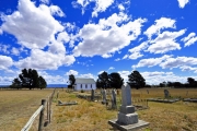
The area is filled with both human and natural history, from Aboriginal to early settlers who made the first arduous trek over the Blue Mountains (they are blue because of the wavelength of light reflected by the oil in the numerous eucalyptus tree leaves) in the early 1800s. The earliest settlers on this particular farm, the Ashe family, are believed to have arrived in the 1840s, one gravestone on the property, at the now abandoned homestead, for an 11 month old girl named Florence Emmeline Ashe, is dated 1876. There’s another gravesite in the hills overlooking a paddock that dates from the 1840s, likely that of a convict laborer (remember, Australia’s earliest settlers were part of a penal colony).
I was given the freedom to drive, and walk, the property’s dirt tracks in one of the farm’s “utes” or utility vehicle, a 4WD Toyota Land Cruiser, sampling its landscape, woods, river and wildlife. The farm, more accurately a ranch, is made up of rolling hills and pastures (paddocks in local parlance) and a variety of trees, including eucalyptus, ironbark and yellow box (honey from the latter two is delicious, while ironbark, which looks a bit like American cherry, is rot resistant and burns very well, pieces of 100 year old former fence posts burned continuously in the house’s two wood stoves). The area is also rife with wattle trees, whose brilliant yellow flowers are almost painful to look at. Without the moderating influence of the sea, the air temperature range, it’s late winter here, varies from a low of 25F at night, to a high of 65F during the day. The air is incredibly clear and dry, it’s hot in the sun and cool in the shade. That, along with the absence of light pollution, means stars are numerous, the milky way runs across the night sky like a hazy white wake. In addition to being exceptionally clear, and dark at night, the farm is also very quiet. Ask yourself this, how many times have you stood outside, in the middle of a field, and strained to hear any noise, manmade or otherwise? Between bird calls, this is among the quietest outdoor places I’ve ever been, save perhaps the desert of the US southwest.
The most prominent feature at the farm is 3400 foot Mount Marsden, a sheer promontory named after the cleric Samuel Marsden, to whom this region’s land was first deeded in the early 1800s (he never actually lived here, however). He became senior Anglican minister of the district in 1800, and by 1807 he owned over 3,000 acres, on which he employed convict laborers. In 1809 he was the first to ship wool from Australia to England, and is believed to have been the first to introduce sheep to New Zealand, where he developed a somewhat gentler reputation, while a member of the bench of magistrates of Parramatta, Australia, he was known as the “Flogging Parson”. However, he’s also known to have befriended and cared for a number of Māori visitors and sailors from New Zealand. He cared for them on his farm, providing accommodation, food, work and education for up to three years.
Perhaps most appealing of all are the sights of the winged variety. In the book “Fifty Places to Go Birding Before You Die”, author Chris Santella lists Capertee Valley as one of only two locations in Australia selected in his top 50 world bird watching locations. While I only spent three days there, I’m forced to agree, as a bird watcher it was a feast for the eyes, a few examples of which are attached.
Travelogue Entry #17
Entry #16 – Cruising the Alaska Peninsula – 19 July 2015
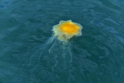
The day begins with brilliant sunshine and a cloudless sky, and the lightest of zephyrs. Mist rises from a nearby but hidden stream, illuminated by the morning light, while I can clearly hear the calls of scores of songbirds ashore. Large tentacle jelly fish float by, easily visible through the clear, glassy water. The air is scented with pine, the temperature is 58, yet it feels much warmer in the sun.
We weigh anchor and head for our next destination. Along the way we encounter a pod of humpbacks feeding in the kelp at the shoreline off our stbd bow, just as we leave the bay. Shortly after this we decide to stop at small twin pinnacle rock islands SW of the mouth of the bay, which support large puffin and gull rookeries. It turns out to be a fortuitous detour as the lighting is ideal, with the sun still low in the eastern sky, there is no wind and the swell remains light. Puffins are in flight everywhere and can be seen nesting in abundance, it’s birdwatching nirvana. After a half an hour drifting near these islets my camera trigger finger is cramped from taking so many photos. We finally depart and see still more whales, both humpbacks and fins, along our route.
After a three hour passage we drop anchor in Ugak Bay on the southwest portion of Afognak Island. The weather remains clear and warm, although breezier than our last anchorage. After lunch we launch the tender and take it up the nearby salmon stream to a weir at Litnik, the site of a former native village, which is now a small Alaska Department of Fish and Wildlife counting station, it’s low tide and we just barely make it up the stream. We hike about two miles up a dirt road from the boat landing to the station. As we walk along the heavily forested trail we pick and eat ripe salmon berries, which are delicious (those with a slightly black tint are the sweetest). A young woman is working at the station; her boyfriend is back at their boat which is anchored near ours, a Valiant 40 named Starship, which they live aboard in the off season, when not working at the weir. She gives us a tour, there are dozens of salmon on the downstream side of the weir, but she says that’s really nothing, not even worth counting. The cabin they use is interesting, solar powered, equipped with a single sideband radio, LP gas refrigeration, and a large garden, not a bad way to spend 5 months if you like the outdoors. She said there are times when 50 eagles congregate on the rocks in the river to catch salmon. Later in the evening, after dinner, her boyfriend stops by Venture on his way back to the weir to visit with us. He explains they both have degrees in biology, although that’s not a requirement for the work, one only needs to have a high school education and be a resident of Alaska. They seem to enjoy the work and the isolation, although he admits they do get lonely at times. They have a small dog for companionship, and a bear visits the stream regularly, as do elk.
Before turning in for the night at 10PM I note that sea otters have us surrounded, naturally curious there are at least eight scattered around Venture at all points of the compass.
Travelogue Entry #16
Entry #15 – Cruising the Alaska Peninsula – 18 July 2015
Yet another sunny day, and for each one I’m thankful; we leave the marina at 0730 and head to the fuel dock where we take on 1300 gallons of diesel with the intention of avoiding another stop for fuel before we cross the Gulf of Alaska to Sitka in a few days’ time. We are underway again by 0900, bound for Afognak Island, where we will look for more bears and whales. The sea is glassy calm and winds are light, in our wake we leave snow-capped mountains and Kodiak’s familiar hill top windmills.
On our way into the bay we spy a pod of humpback whales, which appear to be hunting for a meal as they circle and dive. Several show us their tale flukes as they periodically dive deep. After a short four hour run we drop anchor at the head of Saposa Bay, a secluded, well-protected anchorage; Afognak is the largest island in the Kodiak archipelago. As we set our anchor we encounter a “crying” sea otter, who serenades us with incessant and baleful shrieking that lasts, on and off, for hours.
The humidity is extremely low, and thus visibility in this region is simply stupendous, mountains 40 miles away are clearly visible. This phenomenon is typical and one of the more desirable aspects of high latitude cruising.
The bay we’re in is surrounded by low hills, studded by juvenile evergreens and stumps bleached white, a sure sign the area has been logged, the first I’ve seen on this passage.
Late in the afternoon we sit in the cockpit, bathed in sunshine, sipping tea and eating cookies. It’s delightful, although after about 20 minutes the wind shifts and picks up slightly, driving us inside. After another one of Tony’s delicious dinners, this one consisting of pork chops, new potatoes, broccoli and cauliflower, we sit down to watch a movie, after which we once again retire to the cockpit. It’s 930 PM, dead calm, and the sun still shines brightly, providing enough warmth to now make this retreat very comfortable. Birds are singing, and fish jumping, a woodpecker does a flyby of the cockpit, as if to reconnoiter us as a possible food source. I can hear a waterfall, but can’t manage to see it through the underbrush, although I can see mist rising from the area from which the sounds emanates. While it’s late, the setting is so enchanting I somehow can’t bring myself to go to bed until the sun disappears behind one of the bay’s low lying hills after 10PM.
Travelogue Entry #15
Entry #14 – Cruising the Alaska Peninsula – 13 July 2015
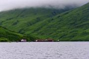
We awaken to steady rain, which squelches our plans to go ashore and explore the derelict cannery. We decide to get underway to make a 100 mile day. However, when retrieving our anchor our windlass fails. I troubleshoot it, in a frigid driving rain, only to find that the negative stud on the motor itself has melted. It seems it was replaced earlier in the season with a used motor, because the new one failed, and I suspect that when the ring terminal was installed the stud was inadvertently twisted, diminishing contact on the inside, which eventually caused it to overheat and melt. Fortunately the anchor was nearly retrieved, making hauling in the remaining ten feet of rode not too arduous. With that, we reluctantly head for Kodiak, 120 miles away, cutting short our trip and bypassing some of the places we had intended to visit. This detour gives us an opportunity to replace a leaking hydraulic hose as well. We proceed up Kodiak’s east side, initially through winding narrow channels fringed by low, rounded green hills, from a distance their surface looks like velvet or a neatly manicured golf course, in near-perpetual rain and mist.
On our abbreviated route we pass Sitkalidak Island; it is here that the massive Shell oil drilling platform Kulluk was cut loose from its tow in a storm and ran aground on New Year’s eve 2012, between Ocean Bay and Partition Cove, a shoreline we cruise past and, knowing the story, scrutinized carefully. It’s inhospitable at best, with steep cliffs and pinnacle rocks. Remarkably, the platform was not dashed to pieces, it remained intact and was later towed off. The Kulluk story makes for fascinating reading, http://www.nytimes.com/2015/01/04/magazine/the-wreck-of-the-kulluk.html?_r=0 Kodiak has seen other such disasters; including the infamous oil spilled from the Exxon Valdez, which enveloped this island, the slick ultimately covering over 1000 square miles of Alaska’s pristine coastline. We pass locations on the chart with names like ‘Dangerous Cape’, ‘Boulder Bay’ and ‘Humpback Rock’. Seabirds are in abundance in this area, the steep cliff faces providing ideal nesting grounds, within a few minutes I spot and identify fulmars and murres of several varieties, puffins, two black footed albatrosses, northern, short tailed and sooty shearwaters and a red-footed pigeon guillemot. We also pass an unlikely outpost, Kodiak’s own private orbital rocket launch facility.
Travelogue Entry #14
Entry #13 – Cruising the Alaska Peninsula – 12 July 2015
This morning is back to normal, it dawns gray and drizzly. We had planned to visit Egg Island to see the puffin rookery, but alas that will not be.
We head into the cannery’s fuel dock at 0900 to take on 400 gallons of diesel (for 3.25/gallon), as we had used fuel at a faster rate than anticipated, potentially limiting our range of exploration over the next week. This supplement solved our problem. We squeeze into a narrow berth, in and amongst trawlers and tenders, to take our fill of diesel.
We are underway by 1100, stopping in for a close look at Egg Island to see if we can see any puffins from Venture, we see a few but no nests. Sadly we must be on our way, pointing our bow east toward our next stop, Olga Narrows and Olga Bay. We pass, on the way, countless set nets, set net camps and set netters. These are solitary fishermen who set nets to the bottom and shoreline, which they check and empty periodically. There camps, small houses and sheds where they sometimes live with their family, are isolated to say the least, often located along otherwise uninhabited shores. Their nets can be dangerous to vessels as they are entanglement hazards.
At 1400 we drop anchor for a few hours in Anchor Cove, on the NW side of Olga Bay. While we pass a few fish camps and an abandoned cannery on our circuit of Olga Bay, Anchor Cove is completely isolated, there are no signs of habitation, and our only neighbors are a couple of herds of harbor seals. Rain showers come and go. Game trails crisscross the luminescent green hillsides, many of which are obscured by low hanging clouds. With some time to kill before returning through the Narrows at slack tide we launch the tender and explore the cove. Seals are abundant and surprisingly not very shy, as are a trio of fledgling gulls, who paddle about a small island (their home nest no doubt), and then climb a small rock where they perch for photos. Along the shore a lone river otter looks at us briefly and then scurries off into the brush. Just as we return to Venture it begins to rain in earnest. We weigh anchor and head back to the Narrows, exploring the shoreline as we go, including an area called Horse Marine Lagoon, Stream and Lake. The shore is dotted with set net homes and sheds, and the hills here, like all those I’ve seen in this area, appear to be a thick carpet of grass and brush stretched out over the rocky surface. The outfall from this lagoon is filled with jumping salmon, and it seems a likely place for bears to congregate, but we see none.
A week has passed and I have been without internet, e mail, save my snail-like, slower than dial up satellite link, and no cell phone, no radio, no news, no anything; it’s glorious.
Travelogue Entry #13
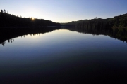
Entry #12 – Cruising the Alaska Peninsula – 9 July 2015
We drop anchor in the NW arm of Castle Bay, in the shadow of sheer 3,000 foot cliff faces, the peaks of which are enshrouded in snow and mist. Blue sky has made occasional appearances, with patches continuing to grow over the last few hours, however, a chill SE wind funnels through the canyon-like walls, as a lone eagle circles over us; outside the sound of dozens of waterfalls create nature’s own white noise. These waterfalls cascade down the mountainside, yet few visibly enter the sea, in most cases they are swallowed by rocky ground, where they disappear beneath it. Periodically great rumbles and booms can be heard, the sound of boulders falling from great heights. Murres bob and kittiwakes circle the boat, the former routinely diving down to the bottom fifty feet below us to hunt for a meal.
Cruising the Alaska Peninsula #4, submitted via satellite: July 10: Venture departs Sutwick Island by 0630, bound for Kodiak Island’s Lazy Bay and Rodman Reach, with a long run today we opt for an early start. The sunrise is magnificent, not something you see often in this region this time of year, and the sea glassy calm. It illuminates the island’s green hills and red cliffs, with each valley and rift creating a deep black shadow. As welcome as the sunshine is, it’s right in the helmsman’s eyes, forcing us to partially lower the shade. Within half an hour of our departure we meet another pod of Dall’s porpoises. They are on a reciprocal course and are gone in an instant, however, the do an about face and race back to our bow, where they remain for three or four minutes, arching and blowing just ahead of the stem. Fulmars and petrels make an appearance, the first I’ve seen on this passage. Off to our port side snow-capped mountains stretch along the coast, located in the Becherof Wilderness area.
Puffins are abundant, however, they are shy and very difficult to photograph. Watching them take to the air is both comical and painful, they often flap their wings on the water’s surface, mostly swimming and partly attempting to fly, it’s almost sad to watch, they are anything but natural born aviators. It seems evolution decided that this was the next step above a penguin where flight was concerned. A long deep swell has replaced the glassy calm sea, these rollers come in from our stbd quarter, they are spaced well apart but very deep, 10-12 feet, as Venture settles into each one it feels as if we are falling into a blue hole. It’s no wonder they are this large, looking in the direction of their origin the next land mass would be Antarctica, making for a long fetch indeed. The peak of Mount Chiginagac, 7000 ft. shakes off its cloud cover, offering a spectacular view off our port side. Within an hour of our destination two different pods of humpback whales blow, arch and show us their flukes.
Cruising the Alaska Peninsula #5, submitted vie satellite: July 11 Lazy Bay, Kodiak: While it was drizzling when we went to bed, today dawns much like yesterday did, bright, clear and sunny. A lenticular cloud hangs over the hills behind the cannery, and the bay is glassy calm. We launch the tender and make our way ashore to visit the Ocean Beauty cannery. Cruising guides and another cruiser tell us it’s not to be missed, but provide few details as to why, other than to say, ‘be sure to meet the plant manager, Woody Knebel, and see his museum and photo album”. From a distance the facility looks neat and clean, however, up close it could pass for a military installation. From the moment we set foot on the dock it’s clear this fish processing plant is cut from a different bolt. I’ve visited many of these and most range from messy to downright repulsive. Not only is there no odor what so ever, this plant is whitewashed from top to bottom, there’s no trash to be seen anywhere, and literally nothing is out of place. We meet Woody in his office, which is a miniature shrine to Kodiak wildlife, natural history and native populations, it’s chock a block with artifacts, antiques and fossils. After chatting with him for a while he offers to give us a tour, during which he proudly walks us through the entire facility, including the “museum” a room he’s created, and which houses an astounding variety of artifacts, from an entire 100 year old wooden fishing dory to antique fish processing equipment and a small functional steam engine. Other areas include the diesel generator electric plant, which houses three large CAT C32 generators, it’s immaculate, a woodshop, metal shop and the heart of the facility, the canning operation. There’s even a small chapel, also Woody’s doing, isolated on a hillside, it’s ringed by memorial crosses from revered deceased employees and pets. At the opposite end of the camp another memorial, a plaque which carries a poem, pays tribute to two fishermen who were lost while working from a small boat out of this facility two decades ago.
There’s been a fish processing plant on this site since 1917, and it was a US Navy seaplane base and radar station during WWII. In other words, there’s no shortage of history. Woody is also an accomplished photographer, his photos adorn the walls of his office and many other rooms throughout the facility. He’s also an accomplished raconteur, sharing both stories of his own, of which there are many, as well as others that have passed through. As we walk the neatly groomed paths between buildings Woody stops occasionally to pick up scraps of paper or cigarette butts, and not without some effort as he suffers from Parkinson’s disease. He’s clearly proud of the facility he keeps, and with good reason. He’s also clearly well-respected by the staff, they all greet him warmly. He says that turnover is extremely low, which means the employees are older than that of the average cannery, which means they are more reliable. The work season is five months and 100 hour weeks aren’t unusual, when the fish are in season, primarily salmon, but also black cod and halibut, they never stop working.
We’re invited to stay for lunch in the “executive dining room”, a small room off the main dining hall. The fair is hardy and delicious, soup, fresh baked bread, roasted pork, hamburgers, with melon, chocolate cake and ice cream for dessert. I walk through the main dining room where roughly 200 employees eat at long tables, the food is identical. The large table on which we eat is made from packing crates and other scrap lumber, it oozes character, as each color that’s etched into it tells a story of a different caned brand, Star-Kist, Bumblebee, Alitak and others I’m certain that if it were sold through Williams Sonoma it would fetch $10,000. As we leave we walk by dozens of fishing boats piled high with fish gear, much of it being worked on by crews, nets are being repaired, hulls painted and hydraulic machinery serviced. The salmon season opens again in two days, and they are primed and ready to return to sea. It’s a hive of activity that operates in high gear during the long summer days, which then falls dormant during the longer, and bleak winter months.
Travelogue Entry #12
Entry #11 – Chartwell and Churchill – 25 April 2015
Two weeks ago I spent time in the UK, visiting with clients aboard their 68-foot Nordhavn, which is berthed at Limehouse Marina in London. While there I conducted a day-long seminar aboard this vessel for Nordhavn owners, who came from the UK and Belgium.
Having finished my work I allocated a day to make a pilgrimage of sorts, to a place I’ve wanted to visit for some time, Winston Churchill’s family home, Chartwell, in Kent, south of London. I have a fondness for British historical figures, Ernest Shackleton, Nelson, Frank Worsley (Shackleton’s navigator and the unsung hero of that expedition) and of course Winston Churchill. The breadth of Churchill’s accomplishments are nothing short of stunning, as statesman and prime minister of course, but also as an author (he wrote over 50 books in his lifetime, and countless magazine and newspaper articles, sometimes composing 5000 words in an evening, he typically worked in bed until noon and rarely went to sleep before 4AM), soldier (he fought in various places around the world, from India, the Sudan and South Africa, where he was taken prisoner and subsequently escaped, in the late 19th and early 20th century, to Europe during WWI) he took part in the British Army’s last cavalry charge, at Omdurman in the Sudan, and said of it, “Nothing in life is so exhilarating as to be shot at without result.”. He was also an accomplished artist, having completed hundreds of critically acclaimed works, many of which are on display in his Chartwell studio. His life is replete with quirks and twists of fate. For example, as a young army lieutenant, he injured his shoulder while disembarking from a boat in India. He made note of this in a letter to his mother, his correspondence with his parents is voluminous and much of it is preserved, saying that he could no longer effectively wield a saber, a distinct disadvantage as a cavalryman. Concerned about his ability to defend himself in battle, she sent him a gift, an early semi-automatic pistol called, because if its distinctive round grip, a “Broomhandle” Mouser. Years later that pistol would prove fateful, in the same aforementioned cavalry charge it saved his life, he used it to dispatch three spear-toting dervish opponents who were intent on killing him, his companion was killed. It can be said, therefore, that were it not for this pistol, the fate of the free world may have taken a very different course.
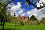
Chartwell embodies so much of Churchill. He acquired it in the early 20s and lived there off and on until his death in 1965 (ten days after my 1st birthday), this year marks its 50th anniversary. He molded the structure into a home where he could be at ease and comfortable with his family, and where he frequently entertained guests from all walks of life, from Chaplin to Eisenhower. An avid brick layer, Churchill built yards and yards of brick walls and even a brick cottage and play house for his daughter mary. He laid so many bricks that the local brick layers’ union made him an honorary member. The grounds are manicured, but naturally beautiful. Two lakes dominate the landscape, along with gardens, woods and copses, swans, geese, and a goldfish pond (he loved to meditate alongside the pond while feeding the fish what he believed was the favorite food, maggots, which he kept in a box next to his chair). The home itself, along with his studio, where he painted and wrote (in fact he frequently dictated his editorial works to an army of typists late into the night) are open to the public. They are well preserved and tastefully presented. Each room is staffed by a knowledgeable attendant, each of whom will happily engage visitors in discussions about the great man, telling stories and answering questions. You can tell they truly enjoy their work. One told me that until her death last year, Mary, visited the house regularly to make sure it looked as it did when her father lived there. No photos are allowed in the house, however, I asked the two attendants at the front door, both of whom looked like retired Royal Marines, if I could photograph the door knocker, an imposing but simple polished brass ring, the door itself is weathered and almost roughhewn timber. They looked at each other and said “why not”. One of them closed one of the two doors to give me a better angle. After I took the photos he pointed out a series of small marks on the door, around the knocker and above it, the latter was in a small group, while the former was more spread out. He said, “Do you know how those got there?” I shook my head, “Winston and his son Randolph used to shoot at it with a pellet gun” he said, “Winston aimed above the knocker, his groups were tight, he was an excellent shot, Randolph’s were at the knocker, he wasn’t as good”.
As I walked through the rooms it was difficult not to be awed, the displays, again they are tasteful and visitors showed the appropriate reverence for them, which was refreshing, tell a story of a man who truly left his mark on the world in so many ways. And while I was awed, I wasn’t emotional, not until I arrived at the final room, which memorializes Churchill’s death and his funeral. Having read many books about Churchill, including William Manchester’s excellent three volume set “The Last Lion”, I felt a connection with this great historical figure, perhaps greater than any other. And thus, as I reviewed photos and watched the moving footage of the funeral procession, I was moved to tears. I used to be self-conscious about this until I learned that Churchill too was noted for shedding tears in public, often while making speeches. Imagine a politician doing this today.
I enjoyed Chartwell enough to return the following day. I awoke to low gray clouds and drizzle, however, by mid-morning it began to clear. By noon patches of blue sky appeared and I was able to get a few more photos of the home bathed in sunlight. Within an hour clouds were few and the sun shone in all its glory. While I very much enjoyed my time wandering the home and grounds of Chartwell, I must confess I felt a strange sense of melancholy too, I don’t get depressed but this was the nearest thing to it I’ve felt. Chartwell is more a shrine than a memorial, a shrine to a fallen leader, the likes of which the world may never be seen again. Perhaps that’s the reason for my gloom.
After leaving I drove through a series of one lane roads, what’s known as a “single track” here, that wended their way through sun-drenched, breathtakingly beautiful countryside, rolling green, very green, hills, dotted with sheep, horses (and a lone mule) and cows, along with the occasional church steeple. Bird life was also abundant, and chicks plentiful. Many fields are planted with rapeseed, which is easily identifiable by its brilliant yellow hue. I’m glad that on a whim I took that drive; as it lifted my heavy heart. Churchill said he bought Chartwell for the views, and now I know what he meant.
In spite of his success and notoriety Churchill was often one step ahead of creditors. On a few occasions he nearly was forced to sell Chartwell. He was a notoriously bad investor and gambler. Invariably, at the last moment he’d secure a lucrative contract for a book or article contract (he was paid well above the going rate, and he earned it), or a benefactor would step in with a loan. Thankfully, he never lost it and it now belongs to the British National Trust. If you find yourself in or around London, I strongly recommend the visit to Chartwell and of course the Kentish countryside.
travelogue # 11
Entry #10 – Turkey – 1 February 2015
Turkey…it’s almost certainly not what you think.
I’ve spent the last week here and it’s been an interesting and eye opening experience. Coming from my previous stops of New Zealand, Australia and China, the contrasts in landscape, culture and food were stark indeed.
I’ll admit, I had some trepidation about going. Most Americans’ perceptions are formed from the news, and for those of us who are old enough to remember it, the movie Midnight Express, about an American drug smuggler who is sent to a Turkish prison. Having traveled extensively I’ve learned not to believe everything I see or hear via American mass media, and I have also learned that the news never depicts a country’s overall demeanor accurately, and Turkey is no exception.
I spent the bulk of my time in southwestern Turkey, in a region known as Antalya, it faces the Mediterranean, with a backdrop of snow covered peaks. The main city has about one million people, in season (it’s off season now, which had distinct advantages, no crowds, lower prices and tourist sites like the Roman ruins, more on these in a moment, are literally empty) that number surges, the bulk of visitors coming from Russia, Germany and other European countries. The climate in this area during this time is not unpleasant, although it is the rainy season. Daytime temperatures are in the 60s, nighttime in the 50s, although these vary up and down ten degrees depending on the wind direction. When the sun shines, and I’m happy to report it did during much of my stay, it’s glorious.
I found the Turkish people to be almost without exception kind, gracious and welcoming. Whenever they asked where I was from, and I answered, I never received anything but a smile and approval. As I walked along a street in the old city a shop keeper spoke to me in Turkish (I grew a beard for this trip, hoping to blend in, it worked! Most people thought I was a local), I responded and after doing so he broke into perfect English, saying, “where are you from?” Being a savvy traveler I’m always careful about these encounters, as they can sometimes be the beginning of a distraction scam. I looked around before answering, then said, “The US”. He then said, “Detroit?!” I said, “no, l Virginia”, to which he responded, “ah, Richmond, I have friends there, are you from there?” These sorts of encounters weren’t unusual, folks generally were curious and friendly.
Turkey is a secular country, however, about 95% of the population is Muslim. This was my first visit to such a country and it too was enlightening. Visiting a country like this is a low impact way for a westerner to learn about the customs and religion. While walking alone along an orange grove (these groves are everywhere, oranges litter some streets, the oranges are very tasty and its permitted for passersby to take one, but just one) one day taking pictures, a small boy approached me and with a big smile said as-salamu alaykumIt (peace be upon you, but it’s used as a ‘hello’ and ‘goodbye’) caught me off guard and at first I didn’t say anything, he fixed his gaze on me, and said it again, and this time I responded in kind. He then smiled again and posed to have his picture taken. On this subject, I heard the Muslim call to prayer, it’s impossible not to, five times a day, in every town and city, and visited a mosque with our guide. As we were inside he explained many of the customs and rules, emphasizing that, as a secular country, Turkey’s approach toward Islam is somewhat less hardline, or aggressive than other officially Muslim countries, in fact some Turkish Muslims aren’t welcomed in mosques of these countries for this reason. When I asked Turks about religion, and I did on several occasions, men and women, some believers some not, all emphasized that they are free to choose and no pressure is placed on those who do not observe the religion or its customs. One young woman with whom I spoke impressed me, an engineer and Fulbright scholar who graduated from UVA, she said, “I don’t believe”. She then said, “…I believe in me”. While Turkey also emphasizes secularity, there is a push among some factions, starting with the current leader, to increase religious education in schools, decrease alcohol consumption, enforce a dress code etc. I met no Turk, men or woman, who approved of this slide toward conservative religious observance. All were proud of the country’s history of religious tolerance, which dates back to the Ottoman Empire. Turkey’s imams are educated by (they must have university degrees) and receive their salary from the government.
From what I could see, however, secularity does exist, on any street you could see a mix of dress, from women modestly dressed with head scarfs, to those who would not have been out of place in NY or LA. By and large, women here do not wear full face coverings or niqab, although I saw a handful of these in Istanbul. Most women on the street in Istanbul wore head scarfs, or hijab. Interestingly, and in contrast to the US and UK, I never saw a civil servant or airport employee wearing so much as a head scarf.
The ancient ruins in this part of Turkey are simply beyond description, easily rivaling those in Italy. They are numerous, there are over 10,000 documented sites of antiquity in the country. Those that have been excavated are essentially open, after paying a small entrance fee you can walk among them freely, and few if any areas are barred to the public. Best of all, as mentioned above, they were essentially empty, it was possible to walk the main avenue of a former Roman city of 15,000 inhabitants, alone. Among the most breathtaking sites is that of Termessos. Perched on a mountaintop nearly a mile high, this former Roman city, which dates from roughly 300 BC to 300 AD, once supported over 10,000 citizens. It’s location was chosen for its defensibility, at the top and end of a narrow gorge, it looks impregnable, it is said that Alexander the Great tried to conquer it and failed. There is but one way up, via a long, narrow winding road full of switchbacks and hairpin turns; it’s easy to see why even Alexander failed in his bid to take the city. We arrived early and while it was raining in Antalya, it was mostly clear in the mountains. Stopping at the remains of the city gate, I climbed up to its base, and as I began to enter the still intact, roofed guard room I was startled by a deer that was sheltering within, it ran past and nearly over me. We walked among the arches, columns and cisterns (these are still intact, still holding water, as is much of the “plumbing” system, and they are cavernous, think subterranean basketball court, they were simply astonishing) for hour after hour. I’ll admit, I felt a little like Indiana Jones, it was thrilling. Our guide led us along a wall and through a wooded path, emerging he stopped and sweeping his arm as if to say “behold”. The view over looked a stupendous Greco-Roman amphitheater whose back drop was a cloud enshrouded mountain peak. Chills ran up my spine as I took in this vista. At this moment, myself, my client and our guide were the sole inhabitants of this former vibrant city. I drank it in and while a cold wind howled around me I felt warm inside, this was another worldly experience. The sun periodically shone through breaks in the clouds, offering wonderful photo opportunities. Words cannot do it justice, however, I hope the included images provide the reader with some sense of the majesty of this site.
I’m home now. More to follow…including the day I spent in Istanbul.

Travelogue Entry #10
Entry #9 – China – 27 January 2015
Chinese road trip January 27 2015
On the road from Zhanjiang to Guangzhou, a trip of about 5 hours. I’ve flown over this route several times, and have often wondered what it was like 30,000 feet below. Now I’ve had the chance to see it and it has proven to be worth the trip. Before we left I was told, “there’s nothing to see”. Nothing, however, could be further from the truth.
The whole country seems to be a factory, at least until you get out of the population centers, every home seems to be producing or selling something from bricks to rebar, bamboo poles, propane tanks, electric motors, and trailers to fruit and vegetable stands, toys, plastic furniture, I could go on, there’s seemingly no end to what’s made here. On the subject of manufacturing, the country also never sleeps, it’s not unusual to see bulldozers and welders operating by floodlight. Last night, just outside the yard where I’m carrying out an inspection, a group of men were disassembling a fence by car headlights, their cutting torch lighting up the night sky as bats flitted around them, attracted to the insects that were in turn drawn to the acetylene light. Each piece was carried away on a motorcycle. Once the fence was disassembled a large crane drove in and removed what it was formerly surrounding, a now defunct electrical transformer about the size of a VW Beetle. The land is being cleared for a new building.
Secondary roads are bone jarring for the most part, no flat stretch is more than twenty feet long it seems. Once on the motorway, however, it improved considerably and is comparable with those in Europe or the U.S. with one exception, the grade changes rapidly, creating a frequent sort of ‘whoop di do’ motion. It’s not uncommon for cars and even large trucks to drive on the shoulder, nor is passing on the right. Large trucks abound, carrying all manner of goods, from LP gas to giant steel girders, produce and livestock, mostly pigs. It’s also not unusual to encounter pedestrians, motor cycles and three wheel ‘carry alls’, a sort of cross between a small pickup truck and a motor cycle, on both shoulders, sometimes moving with traffic, and sometimes against. Speed cameras abound.
Once out of the city there actually is countryside and wooded hills in this part of China, something most visitors to China never see. Still it’s deceiving as its anything but natural, as even this area is mostly agricultural, rice, fruit groves and grazing water buffalo. I could see farmers tending small plots fenced in by bamboo, often accompanied by a dog and water buffalo, rice husks were being burned in several areas, adding to the already heavy haze.
Stopping at a motorway rest stop was enlightening, and a far cry from I95or the New York State Thruway. The Chinese version is somewhat different, vendors sell mostly fruits and vegetables rather than fast food, although there is a sit down “China” restaurant (and it’s called just that, “China restaurant”). There is also a public spigot that dispenses hot water for people to use to reconstitute their very popular meal, instant noodles. My companions and I bought about four pounds of bananas and tiny oranges for a dollar. Gas is about $3.20 USD/gal. Speaking of cars, there are roughly 100 brands of indigenous domestically produced automobiles in China, many of which, at first glance, could be mistaken for BMW, Buicks (an extremely popular and highly thought of brand in China) or VW. The latter is the most popular automobile here.
The sun set to our right over low mountains, and like most sunsets in China it’s a blood red orb, thanks to the perpetual haze. Just after it sets we cross the 3km long bridge at Beidau. Scores of barges are anchored in the river, while fish farms and rice fields line it’s banks. One third of the western sky is a vivid diffused pink, again a result of haze diffraction.
Night falls, we pass small villages and clusters of homes and the scarcity of lights is impossible to ignore. The few that are visible look as if they are LED, and but for our headlights the road has no illumination.
Final Reflections
Many small Chinese hotels have parking lot guards, who are accompanied by watchdogs. The dogs are usually cute and friendly and they reassure guests they are on the job by barking all night long.
For my final stop in China I visited a steel boat building operation, Seahorse Marine, run by an interesting and very hospitable couple, a Caucasian man and Chinese woman, Bill and Stella Kimley (she is a former Communist Party youth leader, she has the certificate hanging in her office to prove it) both in their 70s. She is very intelligent and the reputed brains behind the operation, and Bill readily agrees (and so do I). Bill’s interest is building steel trawlers, however, his passion is model trains. He has a massive train room at the yard filled with collectible and operational trains. Seeing it, here, in China could only be described as incongruous. At one point I had a very enlightening exchange with Stella. Bill said that in the States many Lionel trains were melted down during WWII in scrap drive, to be made into bullets that were used to kill Japanese and Germans, and as a result they are spread all over the world. I said, “wow, I never thought of that, what a shame, but it seems sort of poignant, Lionel’s contribution to the war effort “. She looked at me and said, “America fought against the Japanese too?”
It’s difficult not to chuckle at the translations for placards. This is in no way disparaging to the Chinese, Chinese translations in America would, I’m certain, if they existed, be no less humorous.
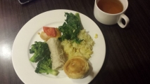
Tea in China is an art form, and it’s nothing like the tea we know in the west. I was served the tea shown in the accompanying image in an airport café. Breakfast, as mentioned in an early post, is also unlike anything westerners are accustomed to, a photo of my last Chinese breakfast is also attached.
The next update will be from Turkey.
Travelogue Entry #9
Entry #8 – China – 25 January 2015
Sunday: I visited a fish market in Zhanjiang this afternoon. Fascinating and surreal would be understatements. Housed in a cavernous building, scores of stalls staffed by mongers selling every imaginable kind of fish, from giant mussels and huge tuna and bass, to lobster, diminutive turtles (I wanted to set them free), clams, shrimp and squid, and something that looked like a fish with legs, it actually walked. They even had horseshoe crabs, I couldn’t imagine eating one. The atmosphere was frenetic, with vendors yelling back and forth aisles at each other as well as at potential customers, and sellers riding bicycles and even scooters between bays full of product, amidst groups of men seated on multicolored plastic stools playing Chinese chess. It was a photographer’s dream, so much character in so many faces, both human and otherwise. Children were playing and working with their parents, while others were eating, or sleeping. One woman scurried, and I mean scurried, past me, she couldn’t have bene more than 5 feet tall, carrying two huge buckets of some type of fish on a pole slung over her shoulders, in traditional Chinese style,
After making our various fish selections we took our “catch” to a cashier, paid for it, walked up a flight of stairs and into a huge dining room, it could have easily held 700 people, although it was mostly empty when we arrived. We were seated, served tea, hot hand towels and within fifteen minutes were eating the fish we’d purchased, all of which was fresh and delicious. The cost, for six people, $150.
Travelogue Entry #8
Entry #7 – China – 22 January 2015
Once again I find myself traveling and working in China, and once again I find myself endlessly fascinated by the culture, the customs and the people. Coming from New Zealand, where I was just a few days ago, and which is marked by its sparse population, the contrasts are stark. This is my fourteenth trip to this China, I’m now relatively comfortable here and have for the most part accustomed myself to the differences.
While it’s fresh in my mind I’ll describe breakfast at the hotel where I’m staying, the ‘Universal International’. While it may be the former, it’s anything but the latter, as I’ve seen no other Caucasians here, I’m the sole Yankee, and virtually nothing is in English, an few staff speak English. I walked into the dining room and like all Chinese eating establishments it’s noisy and crowded. It’s a buffet and every single table is full. I walk around looking for a free table and find none, I ask the bevvy of young hostesses if there any other tables, they just smile. I park my bags at the entrance, with no worry about them being stolen, as the girls look at me and nod, which means ‘ok, we’ve got you covered, go find a seat, and we think you are crazy to be here’. I find a free seat at a long table amongst a dozen men all busily engaged in conversation. I motion to the seat, they look slightly annoyed, but allow me to sit. The man sitting next to me studies me intently, looking at my phone (phones are a status symbol on China), which is in a holster on my belt, that’s unusual in China. Most Chinese keep their phones in little flap folders. If I could have taken a photo of my table, with me in it, without worrying about offending them I would have, it would have been a sight to see. Unlike westerners, Chinese do not take photos in situations like this.
Very little about the food is recognizable to a westerner, at least for breakfast, it’s heavy on fruits and vegetables, fried rice, pretty much Chinese food. There are hard boiled eggs and surprisingly bread, but it’s green, and not with mold. The food is tasty and fresh, and healthy, much healthier than the food I’ve been eating in New Zealand and Australia for the past two weeks. There is an espresso machine, which is very unusual for a true Chinese hotel like this, and that’s perfect because I gave up coffee a month ago. I pick up what looks like a miniature pie in a tin. I’ve been fooled by these ‘it looks western’ scenarios before, however, this time it turns out to be a sort of baby coconut custard pie, for breakfast, of course.
Manners as we westerners know them really don’t exist here, and as a westerner you simply need to get over it, people routinely cut in front of you in lines and jostle you, I’ve been pushed out of a line by 4 foot tall old ladies, they will lean over your plate in a buffet line to see what you have, and they may even cough on it. If I’m sitting alone somewhere, a Chinese will sit right next to me even if other seats are available, light a cigarette, and then start a loud discussion on his cell phone. Covering one’s mouth when coughing, well, let’s say I’ve never seen it happen. In fact coughing without covering ones mouth, and clearing ones throat, as if to spit, are common, and again one just has to get used to it.
When I leave my seat to get another helping and come back to the table there’s a minor argument going on, someone is trying to take my seat and my “clan” is having none of it, they’ve saved my space, one guy pats the seat, motioning me to reclaim my territory. Everyone smokes and while they seemed to respect the no smoking in the dining room and elevators so far, they smoke elsewhere in the hotel.
I finish breakfast and venture out into the lobby and find a seat alone, on a series of huge, carved wooden benches and massive elaborately carved table. I open my computer an begin working. I’m alone, however, within a few minutes I’m surrounded by seven Chinese men, talking and smoking (I’m the only one not smoking), one says hello, and several look at my computer to see what I’m working on, personal space is simply not a part of this culture, nor is fresh air, and little wonder, it’s too much of a luxury. In fact, if you have an open computer in a public space, you can pretty much guarantee that anyone who sits next to you will look at your screen. Eventually I’m the center of attention, they are all looking at me, most smiling, some try to talk to me in Chinese, oh how I regret not being able to speak the language, how interesting an exchange it would surely be.
I’m 5’7” and I tower over most of the folks here, it’s an unusual feeling.
I walk outside to await my ride. I set my bags down on the marble patio and take in the frenetic street scene, which includes cars, trucks, mopeds, pedestrians, a small platoon of marching soldiers complete with AK47s at right shoulder arms. A woman is sweeping and polishing the marble. Her broom crashes into my bags, which is her way of saying, ‘can’t you see you are in my way’, I move my bags to the area she’s already swept and in return I receive a barely discernable bow. The weather is cool and the air remarkably clear, for China, as the smog here is legendary and stifling.
More to come…
Entry #6 – New Zealand – 19 January 2015
January 19
It was with a heavy heart that we departed New Zealand this afternoon. It would be impossible to share too many accolades where this country and its inhabitants are concerned. I’m genuinely sad that this journey has come to an end.
The landscape is varied and almost universally beautiful. While there are endless tracts of unspoiled viewscapes, much of it has also been altered by man, however, it’s been done in a manner that retains its natural beauty. So much of the country is under plow, hoof or managed timber, we drove through mile after mile of rolling hills, dotted, sometimes packed, with sheep, dairy and beef cattle, as well as domesticated deer, and we passed scores of Kenworth and Freightliner trucks hauling large, perfectly round logs whose bark had been stripped from them. Roads, as mentioned in an earlier note, are almost exclusively two lane, excellent, well maintained and fun to drive. They are perfectly suited to motorcycles, of which we saw many, I was aching to ride. It’s challenging to drive and take in the views. Drivers are extremely courteous, often slowing down or even pulling over to be overtaken. I’m not sure I heard a horn more than once or twice during the entire stay. Most notable of all, we rarely saw people, even in all but the largest towns, the whole country looks like it’s Sunday every day.
Grocery stores are well stocked with a wide variety of foods, fruits and vegetables. Most of the latter are locally grown and I made an effort to buy only NZ products, the apples and strawberries were especially good. The wine selection was also good, with relatively good prices for NZ wineries. We shopped for provisions in almost every town we visited. All of the larger supermarkets sold live mussels from tanks. Interestingly, with the profusion of produce available, it wasn’t easy to find a salad on restaurant menus, but there was no shortage of potatoes wedges topped with cheese and bacon. Gluten-free products are extremely popular.
The birdlife, examples of which are attached, is simply breathtaking, at least for bird enthusiasts like me. The morning we left I went for a walk around out cottage to see if I could catch a New Zealand quail, which we had seen on the grounds of the lodging here we were staying a few times. They are shy and scare easily, forcing me to close in on one while crawling on my stomach. The results are attached, they have a Doctor Zeus-like feather growing out of their foreheads.
Farmers in NZ plant evergreen trees as wind blocks for livestock and crops. However, they don’t just leave the trees to their own devices. They are planted very close together, then trimmed into perfectly squared-off rows, hedge-like, with the difference that they are much denser than your average hedge and because they are topped, and intertwined, they are less likely to be blown over. It’s an amazing sight to see mile after mile of these hedges in fields all over the country. Very large, very old trees are not uncommon in NZ, they can be seen everywhere, the trunks of which are often more than five feet in diameter, while reminiscent of those seen in the Pacific Northwest, in most cases they tend to be shorter and much wider. The trees we hiked amongst near Queenstown were 700 years old. Some examples can be seen in the accompanying image, planted along a hillside road in Otago.
Our second rental vehicle, for the south island, was a Holden Captiva SUV, diesel. It was a joy to drive, and the fuel economy was very impressive. In NZ diesel fuel is about 40 cents a liter, at 1.09 NZD, that’s about .85 cents US (a liter is about a quart) less than gasoline, so this was welcomed. Homes are modest and even those that are grand, are grand in an understated manner. I saw no McMansions. Outside of Auckland and Wellington, conspicuous affluence is simply absent. Automobiles are also modest, the most common luxury model being an Audi, and even those were rare.
Each time you check into a hotel, inn or motor lodge in NZ, you are invariably asked by the innkeeper, “do you need milk?”, for your coffee or tea, every room came with a French press. If you answered yes, they would then say “blue or green?” (the color of the bottle caps) or “regular or fit”, which is Kiwi-speak for whole skim milk.
After leaving Dunedin and the enchanted Otago Peninsula, we ventured north toward our final destination Akaroa, which is about an hour and a half outside Christchurch, the airport from which we departed (its large gate area also seemed empty). On the way we stopped at a medium-sized seaport town called Omaru, primarily to have lunch. The town has been shaped by 150 years of timber, railroads, wool and shipping industries, and much of the original granite architecture remains. We had lunch in a café that was once the town’s post office. We then wandered the streets. There were many shops selling locally made products, arts and crafts, however, this was no gentrified tourist mecca, as these shops were interspersed with real, working businesses, metal fabricators, and wool sheds. There was even a working book binder and shoe repair shop. I strolled about side streets taking photos while Sandy and Katie shopped. I sat down outside one imposing shaded granite façade, and simply gazed about the street’s interesting scenery. After a few minutes I looked behind me and noticed I was sitting in front of a book store, and on a whim I walked in. Much to my surprise, located amidst the book shelves, was a faithful replica of the James Caird. The James Caird is a 22-foot wooden lifeboat used, a hundred years ago, by Sir Ernest Shackleton to sail from Elephant Island, in Antarctica, 600 miles north to South Georgia, through what is the most tumultuous sea on the planet, the Southern Ocean (I’ve seen the original, it’s in Dulwich, UK). I’ve retraced this route aboard an ice-class ship and can attest to its ferocity. His successful completion of this voyage, acknowledged as one of the greatest small boat journeys in history, resulted in the rescue of his marooned crew. As an ardent Shackleton enthusiast I was nearly brought to tears at this unexpected find. The shop itself was a veritable shrine to Antarctic exploration. It was a fortuitous find if ever there was one. The shop owner, who was away unfortunately, had obtained the replica after it was used to film a documentary about Frank Worsley, Shackleton’s navigator on this this historic passage (and I would argue the unsung hero of the entire expedition) and a New Zealand native.
New Zealand has a strong connection with Antarctica and Antarctic exploration, many of the early expeditions departed from the port of Lyttleton, not far from Christchurch, and Christchurch airport now houses a US Air Force unit that flies exclusively to Antarctica, we saw their glossy C-130s parked on the ramp when we went to the airport, at the well-marked Antarctic Center. If I was traveling alone I would have surely gone over for a look.
The Akaroa peninsula is a long extinct volcano, called a caldera, one that has collapsed in upon itself and was then flooded by the sea. It’s made for a very interesting and picturesque landscape, with an excellent, well-protected harbor and steep valleys that radiate out from the center to the sea. The small town is a tourist spot. It’s high season here, mid-summer, however, by our standards, and like the rest of NZ, it wasn’t very busy. As it happens, Akaroa has special historical significance, as it is Frank Worsley’s birthplace. The home where he was born is privately owned and immaculately maintained in its original appearance.
Finally, the lamb, beef and seafood, and especially the green lipped mussels were all delicious, and Sandy, Katie and I all agreed, we love Anzac biscuits. And the Kiwis, as I said in an earlier post, they were unfailingly friendly and helpful. Standing on a street with a map opened was a sure way to make friends with locals.
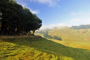
Travelogue Entry #6
Entry #5 – New Zealand – 16 January 2015
In the final stretch of our New Zealand trip. We are in Timaru, about half way up NZ’s south island’s east coast. The trip has been spectacular so far. The changes in weather have been pretty amazing too, right now it’s an astounding 91, really unusual for them, a few days ago we were further south, in Fiordland, it was in the 40s at night.
For the past two days we were in Dunedin. Close to this town is the Otago Peninsula. New Zealanders, Kiwis, like to call NZ ‘The God Zone’, and I can see why, it’s just so beautiful. If that’s so, I’d say Otago is where god goes for a vacation, it’s just indescribably beautiful. When we went yesterday it was pretty foggy, still it was gorgeous, we saw seals, penguins, albatrosses and countless other birds. This morning dawned bright and clear so I went out early before Sandy and Katie were up to revisit some parts of the peninsula, and was rewarded with some spectacular views. It was just breathtaking, I only wish I could have stayed longer.
Last night I went to a local beach and awaited the return of blue penguins, a small colony lives here and they return to their nests each evening about half an hour after sunset. Sure enough they showed up, about six of them while I was there. They are tiny, less than a foot tall.
I’ve attached a small selection of photos.
Some other thoughts about NZ…
- There are so few people, one keeps thinking it’s a Sunday because everything looks deserted. It’s bliss. The country is the size of Italy but has just 4 million people. Only a million on the south island.
- The countryside is surprisingly lush for the most part, all sorts of forests and greenery.
- Nearly all roads are two lane, four lane “highways” are very rare.
- Many of the bridges in rural areas (99% of the country) are one lane.
- The infrastructure is extremely good, and well-kept.
- There’s no litter, none.
- There are active volcanos, we saw a few and had one earthquake.
- Every single town, no matter how small has a public restroom, and all are immaculate.
- Kiwis simply could not be nicer, the only rude folks we met were the proprietors of an Italian restaurant in Fiordland, and they were German.
- The beer and wine, both of which are local, are extremely good, and so is the tap water.
- Hotels and motor lodges have all been great. Many have two beds, one large and one small, perfect for our travel family of three.
- Air conditioning is rare, but it’s usually not needed, today is an exception.
- They have a special type of honey, Manuka, made with pollen from tea trees, it’s to die for. We bought some from a woman who made it herself at a roadside shop in one of the countless small towns thorough which we’ve passed.
- The roads are excellent, often very windy and narrow, a lot of fun to drive.
- Towns are incredibly tidy. In fact, everything is tidy.
- Birds are everywhere.
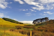
Travelogue Entry #5
Entry #4 – China – 11 October 2014
October 2014
We spent three days in Zhanjiang, which is on the southern coast, working with clients at a ship yard. We then took an overnight train to a small city called Guilin, which is located in a region known for its mountain peaks (some of which are depicted on the Chinese 20 yuan note), caves and rice terraces. Of all the trips I’ve made to China this one was the most “ethnic”, that is, there were very few westerners, and very little in the way of western food or “facilities”. Katie and I stood out, Katie in particular with her light complexion and red hair. We shared our train sleeping cabin with three Chinese, a couple with their two-year old grandchild. They spoke no English, nor did anyone we encountered on the train. Never the less the conductors, all young women, hovered over us, opening the door to our cabin periodically to check on us, and letting us know well in advance of our stop. I motioned for a glass of water at one point to one of the women. Using the universal ‘wait one minute’, index finger held aloft symbol, she ran off and quickly returned with a plastic cup (it looked like her own) of tepid water. I’m pretty sure I’ve never received cold water anywhere in China, nor ice unless specifically asked for (bing quai). The baby was adorable, but he wailed most of the night, Katie slept like a log, I didn’t. As we pulled out of the station the baby’s young parents stood on the train platform waving goodbye, while they both sobbed. I could only guess the child was being sent to live with his grandparents in the countryside so the parents could work in the city, a not uncommon practice in China.
We arrived at our destination at 0400, and were greeted by the guide and driver I’d arranged to meet us. They drove us to our Chinese hotel (thankfully the dining room served coffee, the first we’d seen in days), instructing us to sleep until they returned at 11AM, and sleep we did. We spent the next three days in the company of our 23 year old female guide and our driver, a young man whose English was limited, however, his driving skills were necessarily expert. They were both the epitome of professionalism, although the guide did pad one of the entry fees. I didn’t say anything, it was about $15, and she was so good I couldn’t bring myself to confront her. At one point she asked Katie if she was in university. Katie explained that she had gone for only one semester and then came to work for me. The guide’s eyes grew wide, she then looked at Katie and said “you have a very good father, my parents forced me to go to university to study tourism, even though I didn’t want to do it’.
On a couple of occasions Katie and I walked alone, along a beautifully manicured and illuminated river path in the evening, after dinner. During these excursions it wasn’t unusual for local Chinese people to stop us simply to say “welcome to China” or “how are you”. They seem to possess a deference toward foreigners that would lead one to believe they somehow feel responsible for you and your happiness, it’s refreshing. On Friday and Saturday night we encountered dozens of musicians along the way, some alone, others in small groups and occasionally the Chinese equivalent of big bands, many playing traditional Chinese stringed instruments. None had the western obligatory open instrument case for tips, they did this simply for the fun of it or the bonding.
The first day we spent exploring mountains and large caverns. On day two we drove several hours to visit a mountain top village and its surrounding rice terraces. This village is known for its women and their record-setting long black hair. The only way to reach the peak where the village is located is to walk, there are only walking paths. All goods and supplies are carried up on the backs of residents, along with tourists’ luggage, I winced at the latter as they struggled with especially heavy bags. Trash is carried down the same way, usually two huge bundles balanced on the ends of a long bamboo pole, carried by one person. On one occasion we saw a Chinese woman being carried by two men; she lounged serenely in a wooden “ark”, smoking a cigarette in an elegant cigarette holder, while her two bearers sweated heavily as they trotted her up the path, and later back down. It was a scene straight from central casting.
Once we reached the top we had a delicious lunch which consisted of rice and pork cooked in a one foot length of split bamboo, which is charred over an open fire. The outside of the bamboo was carbon black, while the food within was cooked to perfection. At this, and every meal our guide would take us to a restaurant, order for us and then leave, while remaining at a distance while keeping an eye on us. Occasionally she’d scold wait staff for taking too long or not bringing us what she had ordered (I think). Later, we descended the mountain and left the path to walk among the rice terraces. These terraces had been farmed for over 800 years. We came across men thrashing rice stalks to separate the grains. As we walked through areas where they had already harvested I off handedly commented on the rice on the ground. Our guide made it clear those would be picked up later by children and old women. We encountered two young boys each carrying a liter plastic bottle, into which they were dropping grass hoppers, which are also harvested after the rice. They were covered in mud and having a great time. On the way home an overturned truck brought the two lane mountain road to a stand still, holding us up for over an hour. Driving in China is a bit of a free for all, many roads are two and a half lanes, with the half being reserved for passing, however, there are no dashed lines indicating when it’s safe to do so for each direction. That’s bad enough until you consider most roads are also choked with cars, trucks, busses, scooters (often carrying families of three, including an infant) few wear helmets, and a sort of home-made three wheel cross between a pickup truck and horse drawn cart, which is propelled by a belt-driven modern equivalent of a make and brake engine. It’s a wonder I don’t see more mishaps on my Chinese road journeys.
On our final day we journeyed up a river on a small flat bottomed ferry, in company with about a dozen other similar vessels, each carrying about 75 people. The scenery was straight out of the movie ‘Sand Pebbles’, with men poling small rafts filled with vegetables, semi-submerged water buffalo, sheer cliffs, shore side boat builders, and fishermen who used tethered cormorants rather than hooks and lines. The “galley” of each vessel was on the fantail, and open air, using a diesel stove. While the lunch they served wasn’t the best we’d had, it was still very good, and only made better by the scenery. After lunch a woman walked around the open observation decks serving a Chinese aperitif. Always interested in sampling the local food and beverages, I was inclined to try it, until she came closer, and I spied the speckled snake neatly coiled up inside the bottle.
Sadly, these otherwise picturesque areas are, like most other parts of China, plagued by chronic smog. Fifty years ago it must have been spectacularly clear.
After leaving the day-long ferry ride we passed through a crowded market filled with all manner of shops and stalls, most of which sold locally made crafts and goods. Our guide warned us repeatedly to beware of pickpockets, which seems to be the worst common crime one encounters in China. We clutched our bags as we walked through the crowded streets, Katie was in search of a tea set, but she was too timid to bargain; I, however, happily did so on her behalf. We walked into one shop, she picked up a water buffalo bone into which an ancient scene had been carved. I asked if she like it, she said yes and I asked the shop keeper the price. With a calculator she showed us the number, in Chinese yuan. I did the conversion for Katie, and she shook her head, it was too much, about $20 US. I used my phone and showed the shop keep the equivalent of $10. Shaking her head vigorously she pounded out the equivalent of $15 and held it up. Katie declined, deciding she really didn’t like it that much. We thanked her and left, however, we weren’t free of the shop keeper, she trailed us for two blocks, holding up the calculator with successively dwindling numbers. I finally said to Katie “the price is right, about $3, buy it, please!”. She declined, she had decided she didn’t like it after all, and that was that. However, we’d learned the trick, if you really like it and the price isn’t right, walk out. We bought two carved wooden aromatic combs using this technique, and ultimately the tea set, which at the tea plantation we visited the day before was about $70; at the market we paid about $20, which was still probably too much.
There’s so much more I could write about this trip and China in general, however, I’ll end it here for now. As many times as I’ve been to this country, I find each and every visit intriguing and a new adventure.
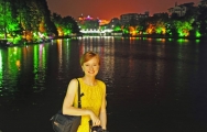
Travelogue Entry #4
Entry #3 – Helgoland – 4 May 2014
The Fleming 58 arrived at Helgoland at about 0100 on Sunday, after a rough ride though the North Sea. We passed scores of commercials vessels large and small, as well as several wind farms, an amazing sight, seeing dozens of huge windmills far out to see. Overall, all went well, the boat took a pounding and shook it off in gracefully, the passage and vessel will be the subject of an upcoming article in PassageMaker.
We were stopped by the Dutch Coast Guard shortly after leaving the Netherlands. Mostly routine, however, they did note that I failed to get my passport stamped in the Netherlands, however, they noted it was Dutch custom’s fault not mine. Without that stamp I’d have a hard time leaving Germany, since my last port of entry was the UK. They said they’d let the German authorities in Helgoland know. Sure enough, when I tracked down the customs officers in Helgoland early Sunday morning, I walked into the “Zoll” office and they said “you must be Mr. D’Antonio”. Those Germans live up to their reputation for efficiency.
As I often say, it’s all about the destination and this destination doesn’t disappoint. Helgoland is an enigmatic locale, picturesque with a rich and at times violent history. It was seized by the British during the Napoleonic wars, to better effect the blockade on Napoleon’s Europe. In the late 1800’s the British traded it back to the Germans in exchange for Zanzibar, in Africa. During WWII it served as a submarine and ‘snell boot’ base. The allies bombed it to kingdom come, something I mentioned in the previous e mail.
Today it’s a resort island, completely rid of all unexploded ordinance, a massive project, with a profusion of charming and very good restaurants (the seafood is outstanding, I’m a mussel connoisseur and had what are likely the best I’ve ever had in my life), and guest houses as well as a profusion of duty free shops (the island is tax-free) stocked with every imaginable type of liquor. Germans come here by the boat load, literally, for day trips and weekends, in most cases they are ferried ashore from miniature and very handsome cruise ships, by local sturdy, and immaculate white, lapstrake wooden launches, expertly driven by the island’s coxswains.
The local brochures describe the weather as pleasant. It may be if you are a North Sea seal, it’s chilly and windy much of the time, it is the North Sea after all. However, that’s relative, it was in the 50s today, and eventually partly sunny, and I saw German tourists in bathing suits swimming on the neighboring island of Dϋne, a sandy outcropping that’s a thousand yards, and a five minute launch ride, from Helgoland proper. It’s possible to find raw amber on Dϋne’s beaches. It’s also the home of the local airport, and a few herds of seals, which I’ll test out tomorrow on my flight to Bremerhaven.
The real attractions are the natural wonders, the landscape, much of which was literally rearranged by bombing during and after the war, as well as the bird and seal colonies (a very small selection of photos is attached). There’s a gannet colony (these are the whitish birds with buff colored heads) that is simply amazing, thousands of raucous nesting birds, many resting on eggs, (tellingly most nests include knots of fishing line); they are so close you could touch them. I could have watched them all day, their gliding and acrobatic flight displays are simply awe inspiring. The seal colony on Dϋne is equally as accessible and photogenic. Heading to Bremen tomorrow, overnight there then home Tuesday.
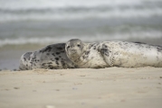
Travelogue Entry #2
Entry #2 – UK to Germany – 3 May 2014
This past May I made a passage aboard a Fleming 58, from Southampton in the UK to Heligoland, a small island off Germany’s North Sea coast, by way of Dover and Scheveningen, the Netherlands. I then went on to Bremerhaven and Bremen after disembarking. I sent updates to many of you during the passage, along with a few photos.
Using four cameras and a variety of lenses I shot well over 1,000 images, attached are a small selection, all in low resolution. A larger selection will be available on my new, soon to be released SDMC website, which will include photo galleries.
Travelogue Entry #3
Entry #1 – UK to Germany – 1 May 2014
The voyage from Dover started out deceptively docile, we departed there at 2000, it was the proverbial mill pond, not exactly what one conjures up when thinking of the English Channel. Things changed for the worse around midnight, it was the proverbial calm before the storm, literally. We’ve sought refuge in a small Dutch harbor, Scheveningen, just north of Rotterdam.
As an aside, for a history enthusiast, one passes so many important locales when cruising in this area, particularly for those with an interest in Napoleonic, WWI and WWII, and aviation history, including the Solent’s Napoleonic forts, the Zeebrugge (Belgium) Raid of WWI, the heroic miracle of the Dunkirk to Dover sealift, the St Nazaire Commando Raid of WWII and of course the D Day landings on the beaches of Normandy, it’s nearly endless. As we departed Southampton, we passed the former Sunderland Flying Boat base at Calshot, perched on a wind-swept point jutting onto the mouth of Southampton Water. From this slipway the enormous, four engine seaplanes departed to patrol the Channel, North Sea and North Atlantic…and sink U boats. The British ‘High Speed Flight’ group, which prepared for and won the Schneider trophy sea plane races, three times in a row (enabling them to retain the trophy indefinitely, it and two Supermarine Spitfires, a seaplane and fighter, are on display in the Southampton air museum), in ’27, ’29 and ‘31, twice at this location, operated from this base as well. Because it housed submarine pens and naval vessels, Helgoland was the subject of many bombing raids during WWII, one included, remarkably, nearly 1000 aircraft. The landscape was literally rearranged as a result of these many raids.
The North Sea beat us up pretty badly last night, sustained 35 kts on the bow and short period, breaking 7-foot seas, the boat did very well, no major casualties, the crew is another story, we were bedraggled to say the least. When we came into the port it was filled with fishing trawlers, perhaps even they wanted out of it (probably not, they are no doubt accustomed to it). We came in here this morning to lick our wounds and recover, have a meal and provision, the wx forecast is improving overnight. We plan to get underway again tomorrow morning with an anticipated arrival in Helgoland early Sunday morning.